(from Newsletter23, Autumn 2007)
This is an extract from a paper entitled ‘Marches and Coldrain: exploring the place-names of boundaries and assembly sites in east central Scotland’, which Simon Taylor gave at the Mary Higham Memorial Day Conference held at the University of Lancaster, 3 February 2007. (Photos by author except Figs 1 and 2.)
I want to take you on a virtual walk through the eastern Scottish countryside, which will at the same time be a walk through time – the kind of walk which Mary Higham so loved. The area I will talk about is on the border of the modern Fife Council area and Perth and Kinross Council area. Perth and Kinross is historically and geographically a very unhelpful administrative unit covering much of east central Scotland. It is much more helpful if I use for the area I am talking about the pre-1975 designation ‘Kinross-shire’ – one of Scotland’s smallest counties, which sits between west Fife and south-east Perthshire, and completely surrounds Loch Leven. Kinross-shire was historically always much more part of Fife than Perthshire.
The parishes involved are those of Cleish in Kinross-shire and Dunfermline in Fife – although in the medieval period, both Cleish and Dunfermline lay in the sheriffdom of Fife. It was not until 1685 that the small sheriffdom of Kinross was greatly augmented by the addition of several parishes, including Cleish.
Medieval monasteries were well-known to have been punctilious neighbours when it came to boundaries. Usually in any boundary dispute we see only the final agreement, and not the years of discord which preceded it. Also, because it is often only the agreement which has survived, and everyone is trying not to ruffle feathers, it is usually difficult to decide which party, if any, was the aggressor. However, there are two boundary charters preserved in the cartulary of Dunfermline Abbey (hereafter Dunf. Reg.), known as the Dunfermline Register, which strongly suggest that in these 2 cases, at least, it was the monks who had orchestrated some kind of offensive on their neighbours. These two charters record perambulations which were made in the same year, 1231, and possibly even on the same day or consecutive days, along the northern and eastern marches of one land-holding belonging to the monks – that of the forest of Outh in the northern part of the large parish of Dunfermline. The 2 charters deal with different stretches of this boundary, and with different neighbours, but record that exactly the same settlement was made with each neighbour. That settlement required each of the secular neighbours, both confusingly called Gilbert, Gilbert of Cleish and Gilbert of Crambeth, to pay to Dunfermline Abbey 10 shillings a year in return for the abbey’s quitclaiming all right which the abbot and convent of Dunfermline have had or have said that they have in the previously disputed land. So in effect the 2 secular lairds pay to stop Dunfermline hassling them along this boundary.
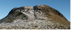
I want to concentrate on only one of these perambulations, Dunf. Reg. no. 192 (translation given in Appendix, below). It concerns the march between Outh and Cleish. Outh comes from Gaelic uchd ‘breast’, hence ‘rounded, breast-like hill’ (see Fig.1).
The lands of Outh are almost entirely upland, lying at around 300 metres above sea-level. It was royal forest until King William I gave it to his illegitimate son Robert of London around 1200, ‘with the injunction that no-one was to fell timber or hunt there without Robert’s permission’ (RRS ii no. 463). Shortly thereafter Robert gave it to Dunfermline Abbey in return for the abbey’s quitclaiming of an annual income of 6 merks from another of Robert’s Fife lands (Dunf. Reg. 167). Its use as a hunting area, as well as a source of timber, and no doubt also peat, would have been continued by the monks. However, aerial photography has shown much activity of a pastoral and arable nature in the area round Outh Hill, the centre of the medieval lands of Outh.
For the details of the 1231 dispute between Dunfermline Abbey and Gilbert of Cleish, see Appendix below. Let me take you through the perambulation from the beginning. It starts at the outflow of Loch Glow, then goes between the ‘north loch and the middle one’, which must be modern Lurg Loch and Dow Loch. There is a distinctive natural ridge which divides the 2 lochs, and which is clearly the start of a medieval march.
The boundary continues in a pleasing symmetry: having gone between the north and middle loch, it then goes between the north and middle hills called the Inneans. This refers to a series of elongated hills, running parallel to each other in a roughly east-west direction. The name probably derives from Gaelic innean ‘anvil, anvil-shaped hill’, common in Ireland. Note that in the 1232 text, already the Scots plural -is has replaced a Gealic plural inneana or the like.
The march continues ‘and so through (or along) the summit of Dumglow’, the highest of the Cleish Hills, at 379 metres. A Gaelic name, the first element is dùn ‘hill, often ‘hill-fort’, and there is indeed a prehistoric fort on the top. The second element is probably derived from the nearby loch, and it is suggested that it is an old Celtic water-word meaning ‘shining’ or ‘clear’, related to modern Welsh gloyw (same meaning).
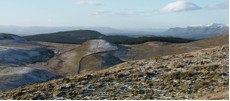
At the top of Dumglow you are at the very edge of the upland plateau of the Cleish Hills. From here you can look down on much of Kinross-shire. The whole flat, arable area between the Cleish and the Ochils to the north was once referred to as the Maw, from Gaelic magh ‘plain, fertile stretch of land’, again much better known in Ireland (e.g. Maynooth, Mayola, Mayo): Old Irish mag in early medieval Ireland basically represented the agricultural heart-land of a túath or people.
After Dumglow the march descends ‘down through the hollow way (le holegath) as far as Cnocenlein, and so by the valley as far as *Fallowmireside’. The hollow way may be the col due west of Dumglow, shown on modern maps as Windy Gate i.e. a road for the wind or a windy road. The gate was probably real as opposed to figurative, as this would have been a convenient access point from the low-lands of Cleish into the hills. However, there is another possible referent of the holegath: down the west side of Dumglow there is a marked groove through which both a modern fence and an unofficial path now descend.
The next stage is problematical, as none of the next four land-marks are identifiable with any certainty. These are Cnocenlein, Falumire, Dumghercloihe and Aldendeich. It is most likely that the boundary continues westward along what later became the parish and county boundary. If this is accepted, then much of it falls neatly into place.
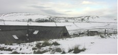
Cnocenlein is probably ‘knowe of the shirt or linen tunic’, Gaelic léine (f.), which formerly also meant ‘linen cloth, linen’ (DIL). I do not know why it was so named. It is almost certainly Black Hill (see Fig.5), along the top of which runs the remains of a large embankment or fail-dyke, probably the containing embankment of the medieval forest of Outh. The hill immediately to the south (i.e. left of picture) is Park Hill, containing Scots park, that is an area that was emparked for the purpose of keeping in game, especially deer.
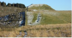
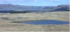
The march then goes ‘per uallem usque Falumireside’, ‘through, by or along the valley as far as Fallowmireside’. It is not quite clear what the valley is, unless it is a mistake for uallum‘embankment’: the original ms (in NLS) needs checking at this point. But *Fallowmire must be the large moss or bog which stretches west from the bottom of Black Hill. The specific element fallow, defined by DOST as ‘withered, sere’ is an exact description of the pale yellow colour so typical of this upland area (see foreground of Fig.6).
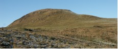
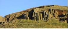
The next land-mark is ‘to the hill which is called Dumghercloihe ‘hill or hill-fort of the short stone’. This must be modern Scaur Hill, where there is no shortage of stones, long and short (see Fig. 7).
From Dumghercloihe we are told that the march then goes as the burn descends into Aldendeich (probably allt an eich ‘burn of the horse’) and so into the Gairney (that part of the Gairney now called the Pow Burn).
In the Atlas of Scottish History to 1707, p.415, Geoffrey Barrow has produced an excellent composite map of various boundaries in the Cleish Hills including the Outh-Cleish one. It is only in this very last stage of the march that his map needs to be adjusted. I agree with him on all parts of this march except for the last stretch, which he takes too far to the west, as far as Wether Hill, marking Aldendeich as the older name for the St Margaret’s Burn. In fact, this latter burn marked the boundary between the lands of Outh belonging to Dunfermline Abbey to the east and the lands of Culross Abbey to the west, as fixed in the agreement reached between the two monasteries in 1227 (Dunf. Reg. no. 213; see Appendix). Thus the land between the Aldendeich and St Margaret’s was a tongue of Dunfermline Abbey lands which reached down into the fertile valley of the Pow or Gairney, and in fact this tongue of land was in the anomalous position until 1891 of being in the parish of Dunfermline but the county of Kinross.
APPENDIX
Dunf. Reg. no. 192:
‘ratione foresti uel alicuius alterius clamii in terra que est inter Cles et forestum de Vueth sicut recognitum fuit per probos homines et per preceptum Alexandri Dei gracia Regis Scocie anno ab incarnatione Christi mccxxxi. Qui recognitores in recognoscendo diuisas inter forestum de Vueth et terram de Cles inceperunt de exitu de Lochglo inter borealem lacum et mediocrem et sic inter borealem collem et mediocrem qui uocantur Yneianes et sic per summitatem montis de Dunglo descendendo per le holegath usque Cnocenlein et sic per uallem usque Falumireside et inde usque ad montem qui uocatur Dumghercloihe et inde sic riuulus descendit in Aldendeich et sic in Goruin’ (for Gornin) … Johanne de Haya, Dd de Lochor, Patricio de Petglassin, Edmundo de Beeth, Johanne de Obiruil’ et multis aliis’
‘To all who will see or hear this present text Gilbert of Cleish (Cles) (gives) salutation. Know that I and my heirs are bound to the house of Dunfermline to pay every year to the said house of Dunfermline 10 s. …. for all time coming … for quitclaiming the right which the abbot and convent have had or have said that they have by reason of forest or of any other claim in the land which is between Cleish and the forest of Outh (Vueth), as has been investigated by honest men and by precept of Alexander [II] by the grace of God king of Scotland, in the year from the incarnation 1231. And these jurors in investigating the marches between the forest of Outh and the land of Cleish have begun from the outflow of Loch Glow (Lochglo) between the north loch and the middle one[1] and so between the north hill and the middle one which are called Inneans (Yneianes),[2] and so through/along the summit of Dumglow (Dunglo) down through the hollow way as far as Cnocenlein,[3] and so by the valley as far as *Fallowmireside (Falumireside), and then as far as the hill called Dumghercloihe,[4] and then as the burn descends into Aldendeich,[5] and so into the Gairney (Goruin for Gornin).’ Gilbert of Cleish appends his seal to the original document, and it is witnessed by five named members of the gentry, mainly local ‘and many others’.
Dunf. Reg. no. 213 Easter (11 April) 1227, at Dunfermline (part of wider agreement reached between the monasteries of Culross and Dunfermline about various disputes which had arisen between them, one of which concerned the Forest of Outh):-
‘quod tales sint diuise inter terram de Quichtis et forestum de Vueth quales fuerunt facte per dominum M Comitem de Fif sub presentia prenominatorum abbatum, scilicet quod incipiant uersus austrum ab aqua de Letheni per siketum q propinquor [sic] est Aldlunahthan uersus orientem et ita ascendendo in directum per lapides usque ad lapidem stantem in monte Sithi et sic descendendo usque ad fontem sub monte et sic per riuulum illius fontis usque in Gorui. It/It quod monachi de Culenr’ firmabunt stagna sua super aquam predictam ubi uoluerint inferius molendino monachorum de Dunf’ hac occasione.
‘Also it was agreed between the said abbots with the consent of their chapters that they would for the sake of peace and usefulness and perpetual quietness cut off all occasion for dissension between the said monasteries, agreeing that such may be the marches between the land of Cult and the forest of Outh as have been made by the lord Malcolm earl of Fife in the presence of the above-mentioned abbots; that is that they should begin towards the south from the Water of Lethans (Letheni) along the syke which is nearer Aldlunahthan towards the east; and so going up in a straight line by the stones as far as the standing stone on Sithi hill, and so going down as far as the spring beneath the hill, and so along the burn of that spring as far as the Gairney (Gorui for Gorni). (And) that the monks of Culross will establish their ponds on the said water where they may wish lower than the mill of the monks of Dunfermline.’
[1] Probably Lurg Loch and Dow Loch respectively.
[2] G innean ‘anvil, anvil-shaped rock or hill’?
[3] Probably G cnoc na lèine ‘knowe of the shirt’.
[4] G dùn ‘(fortified) hill’ + G geàrr ‘short’ + genitive of G clach, ‘stone’ (genitive cloiche, so ‘hill of (the) short stone’.
[5] G allt ‘burn’ + G definite article + ? G each ‘horse’.
Sources and abbreviations: Atlas of Scottish History to 1707, edd. Peter G. B. McNeill and Hector L. MacQueen (Edinburgh 1996); Dunf. Reg. Registrum de Dunfermelyn, Bannatyne Club 1842; G Scottish Gaelic.