An article in the Autumn 2017 issue of this Newsletter outlined the Leverhulme-funded REELS project (‘Recovering the Earliest English Language in Scotland: evidence from place-names’), and explained that one of the main outputs would be an online resource covering all Berwickshire place-names on the Ordnance Survey 1:50,000 Landranger map (Hough 2017: 3). Designed by Brian Aitken, and populated by the other members of the project team at the University of Glasgow, the resource was launched on 17 November 2018, at a joint conference of the Scottish Place-Name Society and the Scottish Records Association held at the Scottish Storytelling Centre in Edinburgh. It is now freely accessible at www.gla.ac.uk/reels.
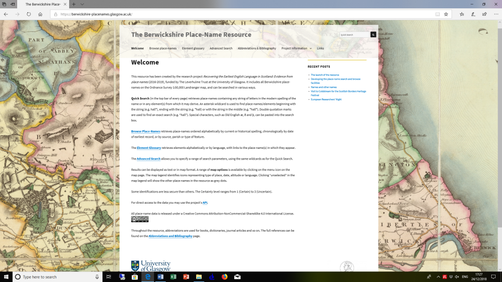
Figure 1 shows the home page, with the four main types of search options: Quick Search, Browse Place-Names, Element Glossary and Advanced Search. The most commonly used (according to Google Analytics) is Quick Search, which retrieves place-names containing any string of letters in the modern spelling of the name or in any element(s) from which it may derive. Special characters, such as Old English æ, ð and þ, can be pasted into the search box.
A Quick Search for hall retrieves 30 place-names, of which 28 contain the letter string in the modern form of the name. They include Crosshall (ECC), Hall Burn (LMS) and Hutton Hall Barns (HUT). The other two are Herriotshiels (CHK), where the earliest spelling Herriotshall (1854 x 1862) indicates a derivation from Scottish Standard English hall, and Howlet’s Ha’ (WRR), recorded from 1771 and containing the corresponding Scots element. An asterisk wildcard can be used to narrow the search to place-names beginning with the string (hall*), ending with the string (*hall) or with the string in the middle (*hall*). Thus a Quick Search for *hall* retrieves just three of the 30: Charterhall Wood (FOG), Chirnside Hall Hotel (CHS) and Hutton Hall Barns (HUT).
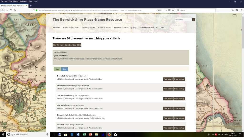
Search results can be presented either as text or in map format, with a range of display options. Figure 2 shows the results of the Quick Search for hall as text, providing information on location and type of feature (settlement, vegetation, etc.). The ‘View record’ option on the right links directly to the full record for each place-name, including historical forms and interpretation.
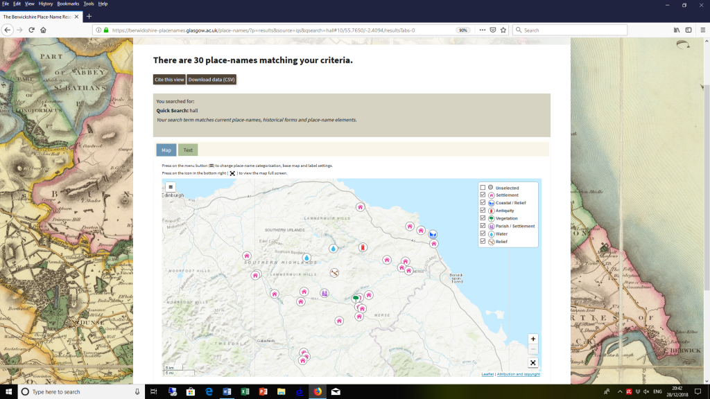
Figure 3 shows the same search results in the default map format, with icons representing the different types of feature. Any of these can be deselected by unchecking the box in the key towards the top right, so as to focus on particular types, such as coastal or water features. The menu icon towards the top left offers alternative ways to view the map. Figure 4 shows the same search results against a satellite background, with icons representing the century in which each place-name was first recorded. Again these can be deselected in order to focus on place-names first recorded within a particular date range. In Figure 5, the background has been changed to the 19th-century OS map, parish boundaries have been added, and the icons represent languages. Various additional options are available, including further OS maps and icons representing altitude, while place-name labels can either be turned on or – to avoid crowding the map – revealed by hovering over the icon with the cursor. The data can also be freely downloaded by clicking on the tab at the top of the screen.
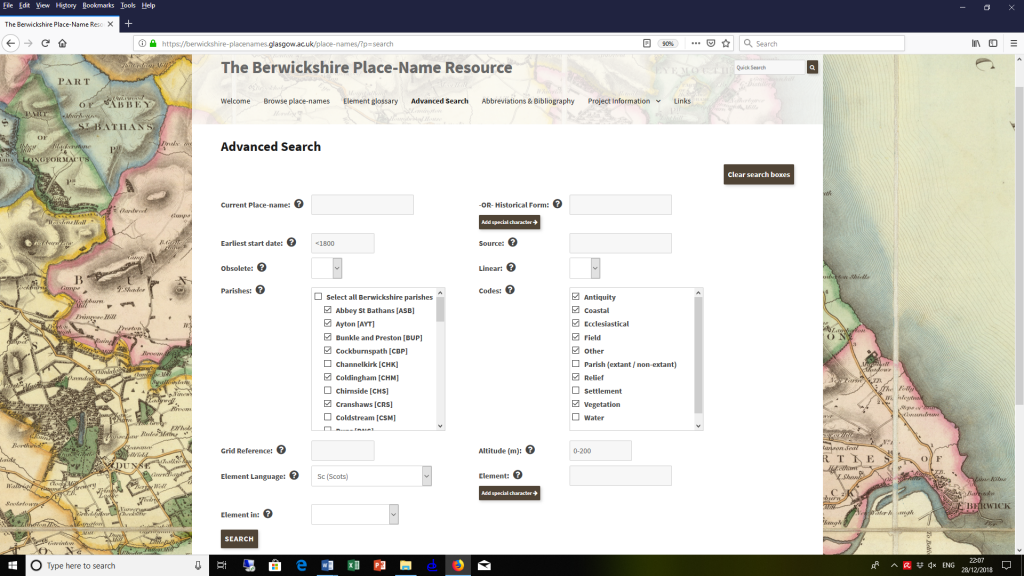
The second search option, Browse Place-Names, offers a route into the data through the current place-name, historical forms, start date, source, parish, or feature type. This allows the user to focus, for instance, on place-names recorded in a selected source or group of sources, or on the names of a selected type or types of feature, or on those situated in a selected parish or group of parishes. Similarly, the third search option, Element Glossary, lists all place-name elements within the resource, but also makes it possible to select only those from a particular language, such as Brittonic, Gaelic, Scots, Old English or Scottish Standard English. Also included here are personal names and others used as place-name qualifiers. In order to undertake more complex investigations, however, we need to turn to the fourth search option, Advanced Search, which allows the various parameters to be combined flexibly.
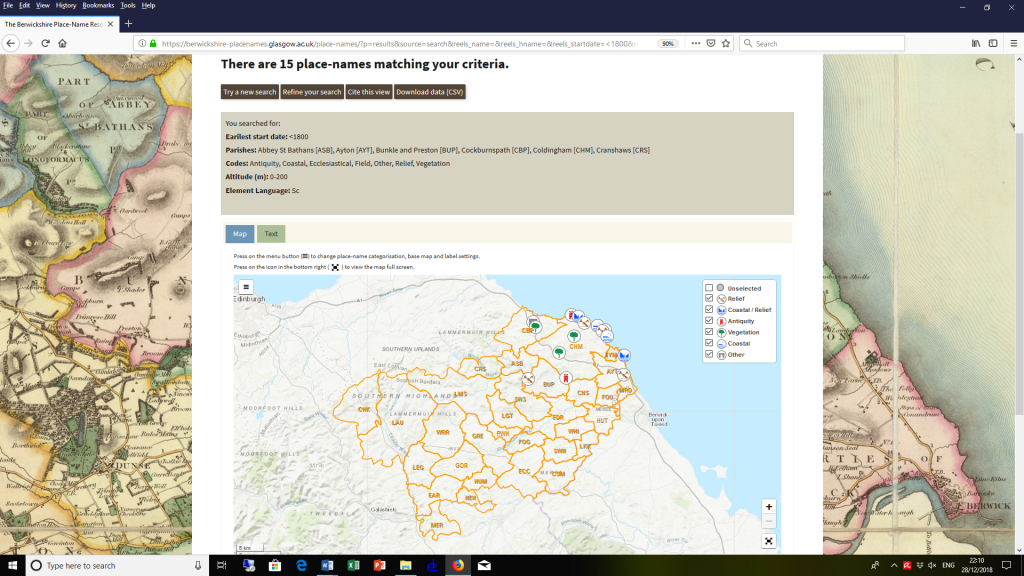
Figure 6 shows the Advanced Search page. The criteria selected in the screenshot are Scots names excepting those of parishes, settlements and water features, recorded before 1800 in the six parishes of Abbey St Bathans, Ayton, Bunkle and Preston, Cockburnspath, Coldingham and Cranshaws, and at an altitude of up to 200m. Figure 7 shows the results of the same search. The 15 place-names returned include the names of antiquities, vegetation, coastal and relief features, and – despite the exclusion of water features – the distribution is closely concentrated along the coastline. Again the map display could be modified to show dates, altitude or other types of information, while the results could alternatively be presented as text. As with all types of search, the full place-name records are easily accessible, and can be displayed or downloaded.
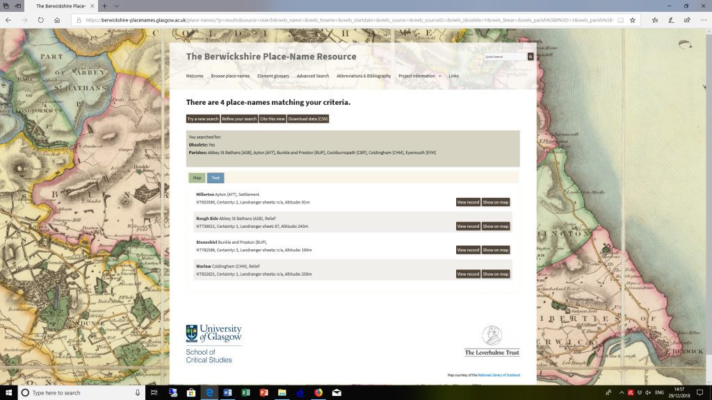
Many place-name derivations, and some locations, are open to doubt, and this is indicated throughout the resource by certainty levels based on a three-part system whereby 1 = (reasonably) certain, 2 = likely, and 3 = doubtful. Figure 8 shows the results of an Advanced Search for obsolete names only, from the six north-eastern parishes of Abbey St Bathans, Ayton, Bunkle and Preston, Cockburnspath, Coldingham and Eyemouth. Of the four place-names returned, Rough Side (ASB) and Warlaw (CHM) have “Certainty:1”, indicating that the National Grid Reference (NGR) is accurate. Millerton (AYT), however, has “Certainty:2”, indicating that the NGR is close to the site, but not precise. Even less reliable is the NGR for Shoneshiel (BUP), where “Certainty:3” indicates only a general location. By following the link to the place-name record, we would discover that it has a single historical form, from Roy’s Military Survey of Scotland (1752 x 1755). This not only accounts for the vagueness of the location but explains why the name has no feature classification. Whereas Millerton is identified in Figure 8 as a settlement, and Rough Side and Warlaw as relief features, the sole attestation of Stoneshiel leaves it unclear what type of feature the name refers to.
The place-name record for Millerton also reveals that the derivation is uncertain. The second element is the common Scots generic toun ‘farm’, but the first, qualifying element may be either the occupational term millar or the corresponding surname. As in all such instances of ambiguity, the place-name is linked to both elements in the resource, ensuring that it would be returned by a search for either. Both possibilities are also discussed in the main place-name entry, which reads as follows:
‘A farm associated with a miller or (less likely) a person or family called Miller’. Given that it appears relatively early, and may have been located by a mill (see below), it probably contains Scots millar ‘a miller’ (also milner etc.) (DOST).
It is the name of a now lost settlement, which does not appear on any map later than Gordon (c.1636 x 1652). It may have been located around NT921598, the site of Prenderguest Mill, to the south of Peelwalls, on the Sharp, Greenwood and Fowler map (1826), later a Saw Mill on the OS 6 inch 1st edn map. The settlement name survives only in the name of Millerton Hill (at NT910591).
The last sentence of the entry serves to explain why the resource includes a small number of obsolete names, despite being based on the OS 1:50,000 Landranger map. They are the exceptions, but are required in order to account for derived names that appear on the map, such as Millerton Hill.
The REELS project includes doctoral research being undertaken by Dàibhidh Grannd, whose PhD thesis focuses on the names of relief features in Berwickshire. Whereas the “Code” tab in the Browse Place-Names facility mentioned above allows all 190 relief features in the resource to be identified, much more nuanced searches are supported by the Advanced Search. For instance, by combining search parameters, we can establish that three of the 190 are now obsolete, seven are recorded before 1400, 21 have an altitude of below 100 metres, 74 derive from Scots, and so on. Useful statistics can also be generated for the names of other types of features. Of the 111 water names, ten are recorded before 1200, in contrast to just two of the 118 vegetation names, and only one of the 41 coastal names: St Abb’s Head (CHM). Although there is no direct correlation between the date of creation and date of earliest record, these figures are suggestive, and give some insight into the chronology of feature naming.
In conclusion, the Berwickshire Place-Name Resource has many exciting features, only a small selection of which could be covered either during the launch in Edinburgh or in this summary. Do please try it out for yourselves!
Carole Hough (summarising her paper in Edinburgh)
Reference
Hough, Carole. 2017. ‘Recovering the Earliest English Language in Scotland (REELS)’. Scottish Place-Name News 43:2–3.